Hazards
Our group utilizes satellite and airborne synthetic aperture radar (SAR) data to research and respond to natural hazards such as earthquakes, floods, wildfires, volcanic unrest and eruptions, and landslides. These events damage critical infrastructure and pose risks to human life. SAR has the unique capability to image the Earth's surface independently of sunlight or weather conditions, making it invaluable for hazards research and response. Additionally, repeat-pass interferometric SAR (InSAR) measures time-dependent surface motion with centimeter-scale accuracy that enables us to understand the physical processes controlling these phenomena.
Team members from the Radar Science group perform hazards research and supports several JPL projects and missions, including:
The analysis-ready data products that our team develops contribute to larger NASA initiatives focused on disaster response and research. Our team members regularly support the NASA Disasters program during response efforts.
Earthquakes
Earthquakes occur when faults in the Earth's crust slip due to tectonic forces or from anthropogenic activities like fracking. InSAR is used to measure surface deformation from earthquakes, providing first responders with vital information about the extent of these catastrophic events. For example, the ARIA project generated these data products following the earthquake in Türkiye–Syria on February 6, 2023.

Coseismic InSAR image of the Türkiye–Syria earthquake from Sentinel-1 radar data showing the extent and magnitude of the ground rupture as a result of the Mw 7.8 and 7.7 earthquakes in February 2023. Each “fringe” pattern is equivalent to a ~2.8 cm ground movement along the line-of-sight of the satellite.
Landslides
Landslides are the downslope movement of soil, rocks, and debris that can move slowly (at rates of millimeters per year) or rapidly (at rates of meters per second) causing damages and loss of life. Some landslides exhibit multiple behaviors including both slow- and fast-motion. InSAR and SAR allow us to identify and monitor landslides and better understand the mechanisms that control their behavior. Our team members have several active research projects focused on understanding environmental controls and climate change impacts on landslide behaviors. Our team also contributes to landslide disaster response efforts. Here are some recent press releases related to this line of work:

Mud Creek Landslide Animation Image shows Sentinel-1 InSAR time series for the Mud Creek landslide in Big Sur, CA THe landslide moved slowly for years before collapsing and destroying CA State Highway 1. NASA Earth Observatory visualizations by Lauren Dauphin, using data courtesy of Alexander Handwerger and Eric Fielding of NASA JPL and the USGS 3D Elevation Program (3DEP). Data from Handwerger et al., (2019). A shift from drought to extreme rainfall drives a stable landslide to catastrophic failure. Scientific reports, 9(1), 1569.
Floods
Floods are the most common hazard globally and are becoming more frequent due to climate change and sea-level rise. SAR can detect surface water and flooded vegetated areas during flood events and is particularly useful for flood response efforts due to SAR’s all-weather imaging capability. Radar Science team members that are part of the ARIA/OPERA projects have generated maps from SAR data that show floods, including this one of Rio Grande do Sul in April/May 2024.

Animation shows OPERA Radiometric Terrain Corrected SAR backscatter Sentinel-1 images before, during, and after the May 2024 floods in Brazil. The black colors show low backscatter areas and correspond to water.
Volcanoes
Volcanoes are geological formations where hot liquid magma within the Earth’s interior rises to the surface through vents or openings, ultimately leading to eruptions. Volcanic eruptions can vary in style, intensity, and duration. They are often preceded by signals, such as increased seismic activity, gas emissions, and ground deformation, which help scientists anticipate and prepare for potential eruptions. Despite their destructive potential and threat to people, volcanoes play a crucial role in shaping the Earth’s landscape and are a valuable source of energy. Our team conducts volcano research and supports numerous observatories worldwide by providing analysis-ready datasets, especially during periods of unrest. By developing physics-based models and model-data fusion frameworks, we aim to improve the accuracy of eruption forecasts.

The image of an eruption in the eyes of a radar satellite. (A) Syn-eruption Sentinel-1 interferogram showing how much the ground deformed due to the eruption of Taal volcano, Philippines on January 12, 2020. (B) Distributed opening model showing the “opening” of the ground as a result of a dyke intrusion.
Wildfires
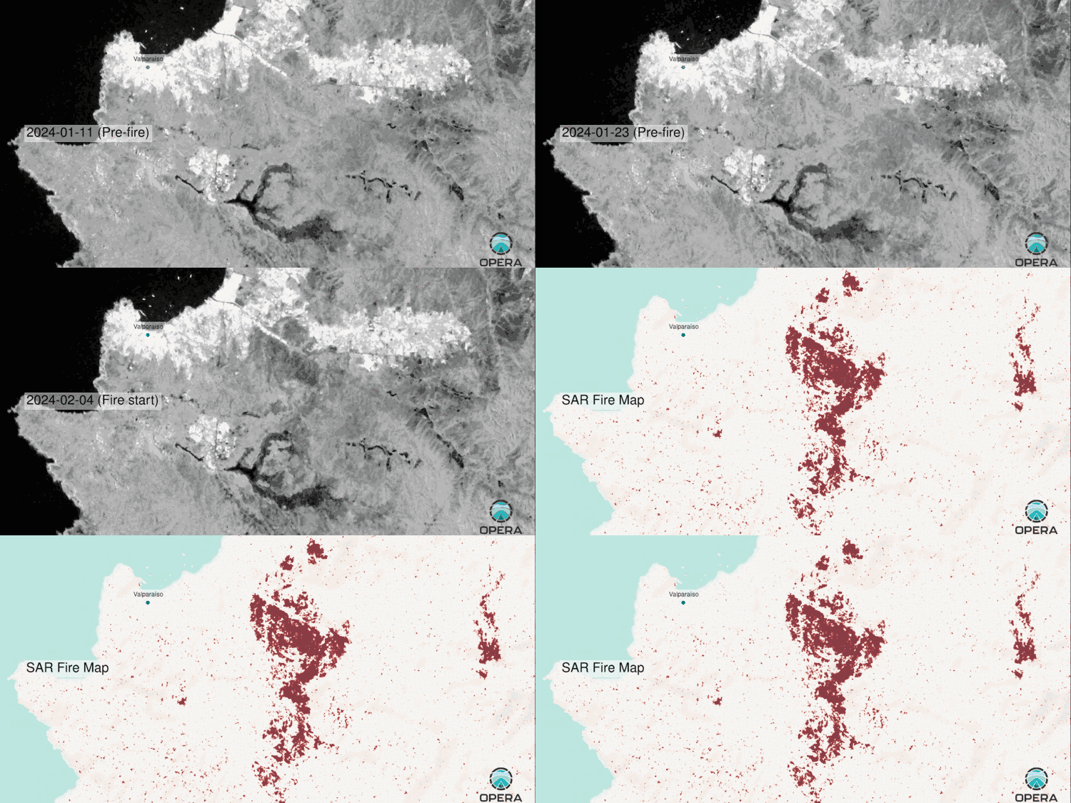
Wildfires are the unexpected burning of vegetation and combustibles. Wildfires can enter urban environments and generate hazardous smoke plumes. Wildfires are becoming increasingly common due to a changing climate. SAR can delineate burn scars through smoke and projected aerosols by detecting changes in scattering mechanisms through time.

Animation shows OPERA Radiometric Terrain Corrected SAR backscatter Sentinel-1 VH images before, during, and after the fires near Valparaíso. Burn scars can be seen as light gray areas become darker indicating a decrease in volumetric scattering; the SAR fire map shows burn scars in red.

Dr. Alexander Handwerger
Joined the Jet Propulsion Laboratory in 2016.
He received a PhD in Geological Sciences from the University of Oregon in 2015 and a BA from Boston University in 2008.
Dr. Handwerger’s research interests are on landslides and rock glaciers. He is currently a Research Scientist at JPL, where he is the PI for the Landslide Climate Change Experiment project, Co-I on landslide and rock glacier projects, and is also the Deputy Project Scientist for the Observational Products for End-Users from Remote Sensing Analysis (OPERA) project.

Mary Grace Bato
Dr. Mary Grace Bato is an Earth Scientist specializing in volcano geodesy, remote sensing, and model-data fusion techniques. Currently, Grace works as a Signal Analysis Engineer at JPL, where she leads the OPERA Calibration-Validation team for the Coregistered Single Look Complex (CSLC) and Displacement (DISP) products. Additionally, she supports the NASA Disaster Program as a subject-matter expert and serves as a rapid response data provider, particularly during earthquake and volcanic unrest events. Her passion is to bridge the gap between fundamental and applied sciences by developing robust and efficient forecasting frameworks and tools that would benefit society using advanced remote sensing techniques.

Simran Sangha
Dr. Simran Sangha graduated from UCLA with a PhD in Geology in 2021. He has been working at JPL since 2012 when he started interning through the Planetary Geosciences, Earth Surface and Interior, and Radar Science groups, before beginning work full time with the Radar Science group as a Signal Analysis Engineer in 2021.
He specializes in using remote sensing techniques to study deformation processes such as those associated with tectonics, hazards, and anthropogenic activities, as well as developing software intended to facilitate the access, management, and use of remote sensing products.

Charlie Marshak
Dr. Charlie Marshak joined JPL as a postdoc in 2017 and then as a signal analysis engineer in 2020. He earned his PhD in applied mathematics from UCLA in 2017, under the supervision of Andrea Bertozzi and Mason Porter. At JPL, he collaborated with Marc Simard to identify forest disturbances, estimate biomass, and monitor mangroves. Currently, he is a member of the Project Science team for OPERA and supports the generation of ARIA’s Geocoded Unwrapped Interferogram. Charlie is passionate about leveraging machine learning and signal processing to enhance the analysis of SAR and InSAR imagery. He also enjoys supporting NASA’s open-science vision via open-source python projects.
CL#24-5887