Sahara Dust Cloud

Dust Particles
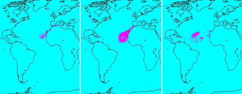
Click on the image for Quicktime movie from 7/15-7/24
A continent-sized cloud of hot air and dust originating from the Sahara Desert crossed the Atlantic Ocean and headed towards Florida and the Caribbean. A Saharan Air Layer, or SAL, forms when dry air and dust rise from Africa's west coast and ride the trade winds above the Atlantic Ocean.
These dust clouds are not uncommon, especially during the months of July and August. They start when weather patterns called tropical waves pick up dust from the desert in North Africa, carry it a couple of miles into the atmosphere and drift westward.
In a sequence of images created by data acquired by the Earth-orbiting Atmospheric Infrared Sounder ranging from July 15 through July 24, we see the distribution of the cloud in the atmosphere as it swirls off of Africa and heads across the ocean to the west. Using the unique silicate spectral signatures of dust in the thermal infrared, AIRS can detect the presence of dust in the atmosphere day or night. This detection works best if there are no clouds present on top of the dust; when clouds are present, they can interfere with the signal, making it much harder to detect dust as in the case of July 24, 2005.
In the Quicktime movie, the scale at the bottom of the images shows +1 for dust definitely detected, and ranges down to -1 for no dust detected. The plots are averaged over a number of AIRS observations falling within grid boxes, and so it is possible to obtain fractional numbers.

Total Water Vapor in the Atmosphere Around the Dust Cloud
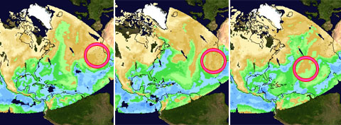
Click on the image for Quicktime movie
The dust cloud is contained within a dry adiabatic layer which originates over the Sahara Desert. This Saharan Air Layer (SAL) advances Westward over the Atlantic Ocean, overriding the cool, moist air nearer the surface. This burst of very dry air is visible in the AIRS retrieved total water vapor product as a region of depressed water vapor (brown in the images) migrating slowly Westward toward the Caribbean. The SAL phenomenon inhibits the formation of tropical cyclones and thus has given the West Indies and the East Coast of the US a respite from hurricanes.
About AIRS
The Atmospheric Infrared Sounder, AIRS, in conjunction with the Advanced Microwave Sounding Unit, AMSU, senses emitted infrared and microwave radiation from Earth to provide a three-dimensional look at Earth's weather and climate. Working in tandem, the two instruments make simultaneous observations all the way down to Earth's surface, even in the presence of heavy clouds. With more than 2,000 channels sensing different regions of the atmosphere, the system creates a global, three-dimensional map of atmospheric temperature and humidity, cloud amounts and heights, greenhouse gas concentrations, and many other atmospheric phenomena. Launched into Earth orbit in 2002, the AIRS and AMSU instruments fly onboard NASA's Aqua spacecraft and are managed by NASA's Jet Propulsion Laboratory in Pasadena, Calif., under contract to NASA. JPL is a division of the California Institute of Technology in Pasadena.
More information about AIRS can be found at http://airs.jpl.nasa.gov.
